Before using any spatial data, we have to have the Coordinate Reference System (CRS), also known as a Spatial Reference System(SRS) correctly defined. Otherwise, anything we do with the data will have to be redone later.
Follow the process below, and the notes below it, to make sure you have the correct CRS/SRS associated with each data layer.
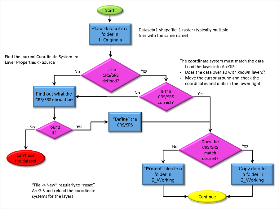
Store the data in a folder for the target area you are working in (e.g. "Humboldt_County") and then in a folder for the source of the data (e.g. Humbolt_County_Website, NationalAtlas). Immediately create a "ReadMe.txt" file in this folder and add your name, the date of download, and the URL or other source for the data. This way, you or anyone else can know where the data came from and how old it is.
All data has a correct CRS/SRS. Your task is to find it. It should be documented in the metadata that came with the data set but this is rarely the case. The web site the data came from may have the information or you may need to track it down. Contacting the organization that provided the data is another approach.
If you cannot find the CRS/SRS for the data, you cannot use it.
Once you determine the "correct" CRS/SRS, unless you are very confident that it is correct, you should check the make sure against a "vetted" source. My favorite are the USGS Topographic Maps which are available on the web for free. These maps are very accurate and contain a great deal of information that can be used to check if a data set is correctly referenced.
Note that many CRS/SRS mistakes are small. The difference between NAD 83 and WGS 84 is a few meters but those between NAD 27 and NAD 83 can be hundreds of meters so you'll need to be careful to make sure the data is referenced to within what is required by the task you are working on.
If the CRS/SRS does not match the one you have selected to work in, you need to "Project" it into the desired CRS/SRS.
In either case, create a folder in your "2_Working" folder labeled for the CRS/SRS you've selected (e.g. WGS84_UTM_10North, WGS84_Geographic).
Note that this may also include a "Datum Transformation".
This may seem like an extra step but having this structure in place in the long run will really help keep you out of a GIS nightmare.
© Copyright 2018 HSU - All rights reserved.